I do a lot of aerial photography work studying photos from all period as possible looking for historic clues of long lost history from Romans to WW2 even post war. In the past i have investigated lots of sites which Heritage England have now listed as historical importance and preserved under acts of law etc. old disused ranges and gun sites, WW1 trench training systems old rail lines, out line of abandon villages, villas and old medieval fields etc. One of my recent studies is an old 3" mortar range now cleared and used by the public.
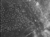
I found the attached war time photo of the area and wondered if the small markings are from 3" WP which was used a lot in this area and are characteristic of how a 3" WP would shed its load forward like a star type pattern, or it could be burn marks revealing the sand beneath or sand blasted forward from the crater fired over a longer distance than short. The ground in the area heath land is of light heather and short grass with a sand base.
Amongst the poc marks are round craters which look like normal 3"HE may be fired at a shorter distance which creates a more of a round crater.
There is a manual about mortar craters and how to spot the direction were it came from and the distance by examining where the tail fin lands and the shape of crater. I also was told how to locate direction and distance by an old boy i knew who was a mortar man observer on 4.2 during the war in Italy, he could locate near spot on where the enemy was firing from. It would be handy to know if the marks on the photo are from WP or maybe something else.